

I need a gps with an error of less than one meter for use in the mountainous area of northern Spain with pine and eucalyptus forests of about 15/20 m high or more. I want to locate several farms that belonged to my grandparents and some I don’t know how to get to them, but I have the UTM coordinates of all of them, so I’m thinking of connecting a GPS to my android smartphone and using an app that has the “Go to” function , which will indicate the direction and distance to the coordinates that I enter in the app. I am thinking of using the “REACH M + RTK GNSS Module” as it has a horizontal accuracy of 5 mm and I assume that under the conditions I have described it would give me an error of less than one meter for real time static use. But I would need to know if this module can be connected to an android smartphone and thus be able to use an app installed on the smartphone with the gps precision that this module provides.
Hello @jstechsp and welcome to the RobotShop community,
But I would need to know if this module can be connected to an android smartphone
Yes, you can use the ReachView 3 app available for Android with Reach M+, you can find more information about it here:
https://docs.emlid.com/reachm-plus/reachview-3/introduction-to-reachview-3
")
The nearest RTK base station is 40/50 km away. Would it be possible to use RTK, via NTRIP at this distance? In the event that RTK does not work or I do not have an internet connection on my mobile in some areas (to be able to use NTRIP), what is the accuracy of the REACH M + RTK module if only the signal from the satellites is available?
The nearest RTK base station is 40/50 km away. Would it be possible to use RTK, via NTRIP at this distance?
If you check the positioning specs
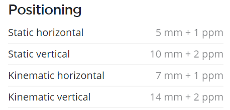
Then the rule for horizontal accuracy is: 5 mm + 1 ppm
So at 40km:
= 5 mm + 40 km * 1000000 mm/km / 1000000 parts
= 5 mm + 40 mm
= 45 mm
However, notice that you will be operating outside of the recommended limits.

If you want to be operating inside the recommended limits, then Reach M2 is a better option for RTK at a distance of 40/50km from the NTRIP station.
You might also want to check out the information about VRS (Virtual Reference Station)
What Is VRS
If you’re working with NTRIP, there’s a good chance you’ll come across this term. VRS or Virtual Reference Station is a useful tool for long baselines.
The density of NTRIP bases and CORS can vary greatly from place to place. If the density of stations is enough, but you are too far from any of them, VRS helps you eliminate your baseline.
Say, you are 70 km away from the nearest station. When working in RTK mode, this baseline is quite long. To create a VRS, your rover sends data back to the NTRIP caster. NTRIP allows the uniting of the data from your rover and the data from dense NTRIP bases and models a virtual base next to you. Thus, your baseline will go from 70 km to 0 km.
The elimination of a baseline helps establish a fixed solution faster and keep it stable.
Thanks, now I understand how this works. Looking at the specifications of the Reach M + and Reach M2 I see that the M2 model would surely work without being outside the recommended range (RTK up to 60 km).
But these devices are designed to be installed on a drone, which flies several meters above the ground.
If I use it connected to my smartphone, on a pole at a height of 2 m, would they work in an acceptable way or is this out of their intended use?
But these devices are designed to be installed on a drone, which flies several meters above the ground.
Not necessarily. Here’s the recommended setup:
Reach M+ needs to have a clear view of the sky approximately 30 degrees above the horizon. There should be no obstacles that could block the view like buildings, trees, cars, humans, laptops etc.

https://docs.emlid.com/reachm-plus/quickstart/ntrip-workflow
I would need to know if when connecting the Readh M + or Reach M2 model to an Android smartphone where I have installed the Reach View 3 app, it is possible I can use it to enter the UTM coordinates of a point that I want to locate on the ground and that in real time (as I go walking through the terrain) the app will show me at every moment the direction and distance to the point that I have entered from my current location.
Or if Reach View 3 does not support this functionality, if I could use an app on the smartphone that does have this functionality (there is some in the play store that has it) and so that Reach M+ or Reach M2 act as an external GPS to the smartphone and they give in each instant my current location. So this app will show in real time the direction and distance to the desired point.
I would also need to confirm if the “Readh M2” model is sufficient for this operation or do I need “Reach M2 w / GNSS Antenna” ?
It seems like your questions have reached the limit of my knowledge about Reach M.
I suggest you ask the manufacturer directly, this is their contact: [email protected]
Or if you prefer I can transfer this ticket to internal support to put you in contact with Emlid.